Apr 16, 2022 - Apr 23, 2022
Fernando de Noronha
This trip has a photo gallery.
🇬🇧
Hang in there! I'm working on translating this post to English. It will be available soon.
Finalmente conhecemos o famoso arquipélago de Fernando de Noronha! Tentamos organizar aqui nossas observações, atividades e algumas dicas. Espero que seja útil e, como sempre, estamos à disposição ali na seção de comentários.
🌊
Já falamos isso antes, mas vale repetir: planeje sua viagem de acordo com a tábua de marés. No Nordeste Brasileiro, maré alta e baixa muda completamente o cenário e as atrações disponíveis. Há diversos sites para consulta. Considere de 0 a 0.4 como maré baixa.
Um aviso importante: você não vai encontrar barzinhos, baladas ou festas no nosso diário. Fizemos uma viagem do nosso jeito: bastante pé na estrada, finalizando o dia com um bom jantar. Se for o seu estilo, venha com a gente!
📺
Temos vídeos curtos de todas as trilhas discutidas abaixo, canoa havaiana, geral da ilha e mais! Se você estiver planejando sua viagem, confira a playlist!
Mapa e Contexto
Para conhecer Fernando de Noronha, é muito importante entender sua geografia e alguns conceitos básicos.
O mapa abaixo é completamente extra-oficial. Para fazê-lo, nos baseamos no Google Maps e incluímos alguns marcadores que iremos referenciar ao longo do artigo.
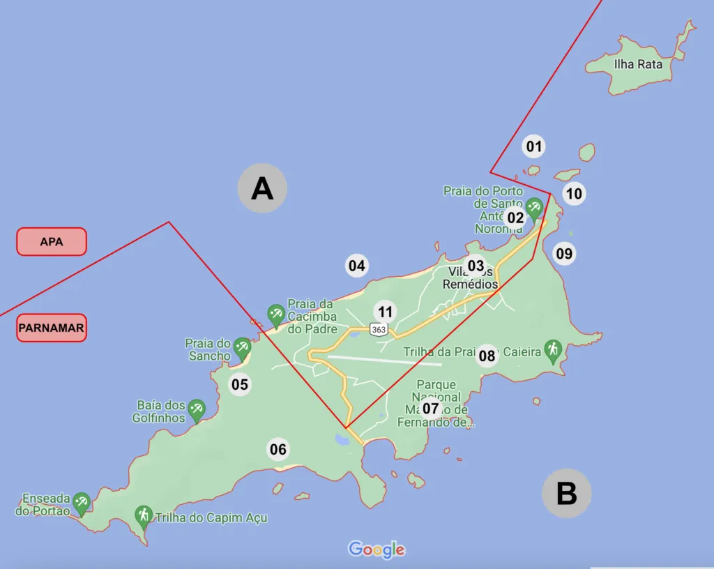
De início, é importante observar:
A e B: representam o Mar de Dentro (A) e o Mar de Fora (B). “Dentro” e “fora” referem-se à posição das praias: “dentro” é o lado virado para Oeste (Brasil) e “fora” é o lado virado para Leste (África). Como resultado disso, as praias de dentro são mais protegidas da correnteza, sendo as mais indicadas para banho. Essa diferença é observada em diversos aspectos da ilha, de forma que o lado de dentro é o mais habitado, enquanto o de fora, o mais selvagem.
APA e PARNAMAR: a linha em vermelho representa uma divisão muito importante na ilha. A parte menor, concentrada na porção Norte da ilha (e no mar de dentro) é a APA - Área de Preservação Ambiental. É onde está a área urbana de Fernando de Noronha. O restante, que inclui todo o mar de fora e outras áreas, é o PARNAMAR - Parque Nacional Marinho. O parque é administrado pelo ICMBio e possui uma gestão bastante rígida. Quando falarmos dos custos e das trilhas, por exemplo, estaremos fazendo referência ao regulamento do PARNAMAR. Por mais que pareça inconveniente, essas regras são fundamentais para a preservação da fauna e flora, assim como para a segurança dos visitantes.
Por fim, algo bastante óbvio, mas que realmente entendi quando estive lá: a ilha fica bastante longe do continente. Para todos os efeitos práticos, você estará no meio do oceano. Isso permite vivenciar o aspecto natural de uma forma muito mais envolvente e nítida do que podemos perceber nas nossas cidades.
Um exemplo bastante simples: previsão do tempo. Em Fernando de Noronha, é basicamente um chute. Pode dar sol, pode chover - por 15 minutos ou dois dias. Por estar tão exposta aos elementos, uma mudança na corrente de ar modifica totalmente o clima.
Durante as trilhas, era muito comum olharmos para a costa e observarmos a chuva. Ora vindo, outrora indo. Teve um momento em que ela nos acompanhou ao longo da trilha, por uns 10 minutos, até que o vento a levou para outro lado, contornando a ilha. Essa apresentação quase infantil do que é estar na natureza foi um dos melhores aspectos da viagem.
Passeios
Ilha Tour
Passeio geral pela ilha. Uma ótima ideia para o seu primeiro dia cheio. O passeio, que dura o dia inteiro, dá um panorama para você se orientar pelo resto da sua estadia.
É oferecido por basicamente todas as empresas de turismo e em diferentes formatos: coletivo caminhonete, coletivo buggy, privativo buggy e afins. Eu não recomendo o coletivo em caminhonete. Víamos esse pessoal na estrada o tempo todo. Você fica entalado na traseira de uma caminhonete com mais 7 pessoas (a maior parte estranhos) e tem um roteiro bastante rígido.
Nós optamos por contratar o guia, alugar um buggy e fazer um tour privativo. Foi uma excelente ideia.
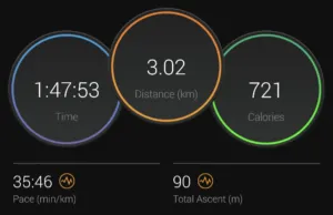
Canoa Havaiana
Passeio de canoa havaiana ao nascer do sol, saindo da Praia do Porto (02).
Deslocamento
Por mais que a ilha não seja tão grande, seu relevo torna o deslocamento um pequeno desafio. Algumas alternativas que utilizamos:
Ônibus: circula apenas bela BR, a rodovia em amarelo no mapa acima. Supostamente passa a cada 30 minutos, mas tivemos que esperar mais que isso algumas vezes. Pagamos R$ 5 por viagem, em espécie. Não considero a melhor opção de transporte se somarmos espera, conforto e conveniência. Por rodar apenas pela rodovia, você fica longe de praticamente todos os pontos turísticos.
Táxi: como é de se esperar, é a opção mais conveniente e mais cara. A melhor alternativa é conseguir o WhatsApp de algum motorista e fechar um pacote de corridas com ele. Fizemos isso e acabou sendo bastante útil - e mais barato do que a tabela convencional de corridas.
Bicicleta: alugamos bicicletas elétricas para um dia. É muito divertido e oferece outra perspectiva aos trajetos. Não são as melhores opções nos morros, mas vale a recomendação.
Buggy: alugamos apenas uma diária, o que se mostrou bastante difícil. As empresas queriam reservas para três diárias, em média. Porém, a oferta de buggy lá na ilha é imensa. É muito provável que você consiga um veículo, mesmo sem reservar. Combustível lá é bastante caro, inclua nas contas. Gastamos R$80 em combustível no Ilha Tour. Se você estiver viajando em 4 pessoas, é uma boa alternativa. Fique atento à Lei Seca e tenha sempre um motorista da rodada.
👟
Obviamente, nós também caminhamos. Bastante. Certifique-se de ter calçados confortáveis e, se for fazer trilhas, que você possa sujar/molhar sem muita preocupação. Inclua algum tipo de tênis, porque fazer as trilhas de calçado aberto é altamente não recomendado. Encontramos alguns turistas que estavam vestindo sapatilhas de natação. Como alguns destinos envolvem muita caminhada em pedra, pareceu uma boa alternativa.
Trilhas
Agora sim, nosso tipo de diversão!
A maior parte das trilhas que fizemos fica dentro da área do parque - portanto, devem ser agendadas. O agendamento é presencial, na sede do ICMBio. Você pega uma senha, fica em uma fila… até que chega aos totens de auto-atendimento para agendar, conforme disponibilidade. Elas estarão marcadas como PARNAMAR abaixo.
Algumas são bastante concorridas. Pensando nisso, deixamos nossa agenda aberta, para poder encaixar as trilhas nos dias e horários possíveis. Grande parte das trilhas também tem exigência de guia. Nós fizemos todas com o mesmo guia e recomendamos muito. O contato dele estará no final do artigo.
Se você gosta de trilha, todas as que fizemos são absolutamente recomendadas.
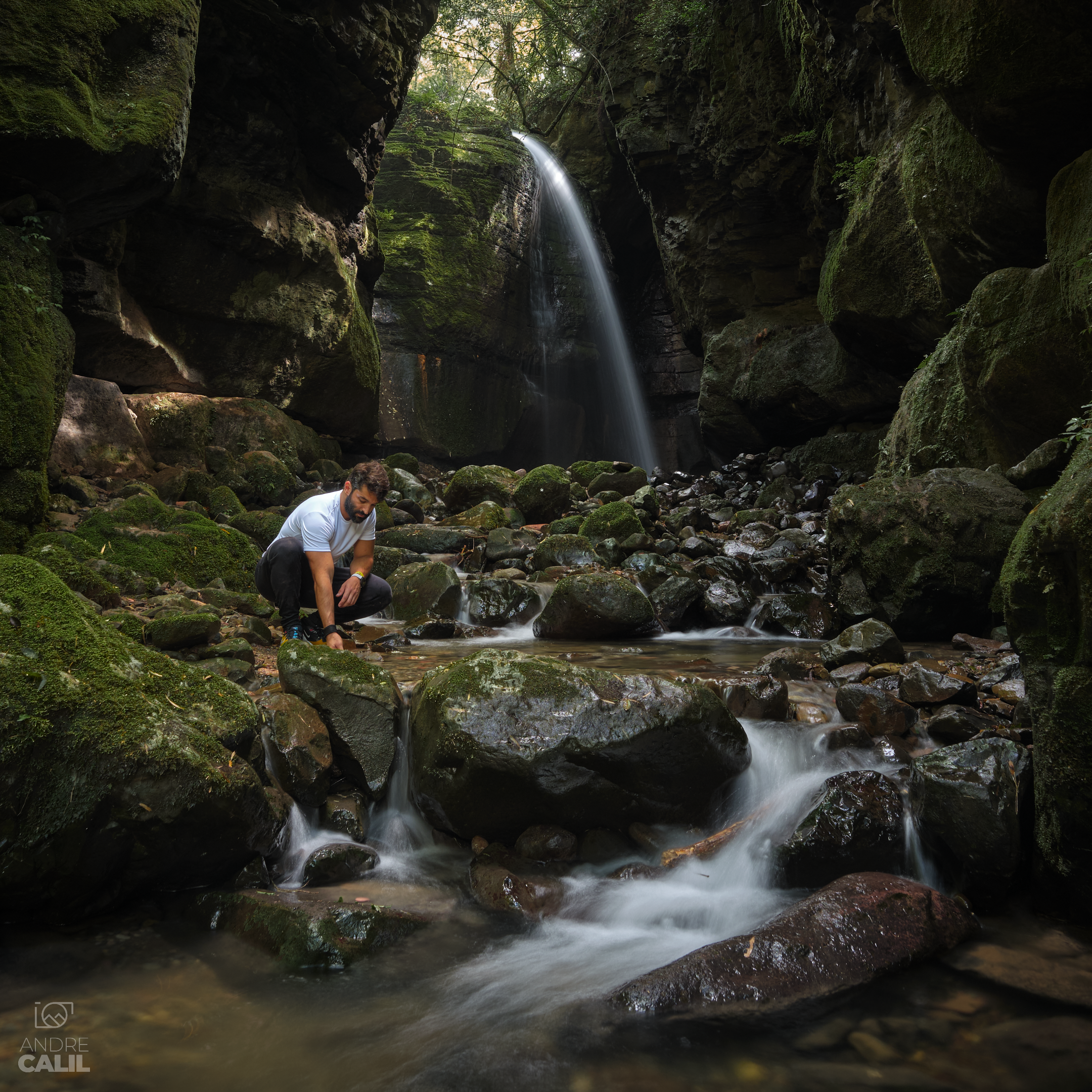
Capim Açu (PARNAMAR, Guia)
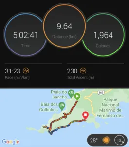
Atalaia Pontinha Caieira (PARNAMAR, Guia)
Equipamento de mergulho é obrigatório - colete e máscara. A primeira piscina, na Atalaia, tem regras especiais de preservação. Você não pode ter aplicado nenhum tipo de dermocosmético - o que inclui protetor solar. Portanto, roupas com FPS são altamente recomendadas.
Do Abreu (PARNAMAR)
Morro São José (PARNAMAR, Guia)
Pequena trilha que leva do Mirante do Francês (10) até a Ilha São José (01). Sim, é uma trilha que leva a uma ilha. Há duas formas de fazê-la: a pé, em dia/hora de maré bem baixa, ou a nado. A última opção exige guia. Foi como nós fizemos e recomendamos de verdade. Não somos nadadores e temos bem pouca experiência no mar. Mesmo assim, com todo o equipamento de mergulho e ajuda do guia, a travessia é super tranquila, rápida e bastante divertida.
Chegando lá, além de uma visão privilegiada às ilhas secundárias e ao Mirante do Francês, você tem acesso a uma piscina natural muito linda.
Não temos registro de duração porque nem pensei em ativar o relógio. Levamos por volta de duas horas, considerando preparativos, travessia, tempo de mergulho e retorno.
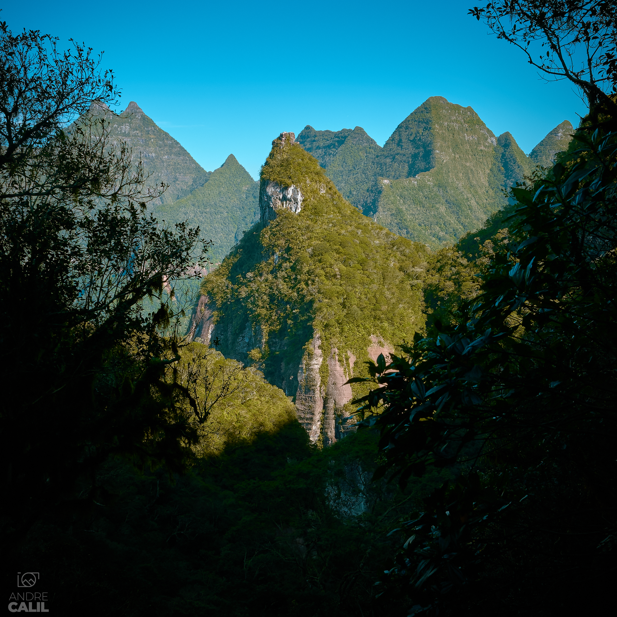
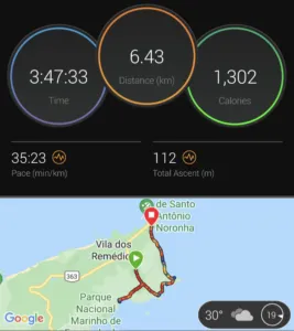
Piquinho
Esta trilha é relativamente nova. Tanto que o início dela nem está aberto, você cruza um terreno com mato alto. Esta foi a única trilha de altitude que fizemos. Você está basicamente escalando um morro anexo à Pedra do Pico, que é o ponto mais alto e um dos principais cartões postais de Fernando de Noronha.
A trilha abre para alguns mirantes que oferecem uma visão única da ilha.
Por não estar na área do parque, ela não é controlada. Não há reservas, tampouco exigência de guia. Contudo, nós fomos com guia e consideramos essencial. Temos certa experiência em trilha e, mesmo assim, achamos o percurso do Piquinho bastante confuso. Há relatos de turistas que passaram horas perdidos, até saírem em alguma praia aleatória.
Outras Atividades
Agrupo aqui algumas atividades que fizemos por conta própria e que valem o registro.
Praias Urbanas
Todo o lado Norte do mar de dentro, da Praia do Porto (02) até a Cacimba do Padre, forma uma área conhecida como praias urbanas (04). Elas estão no perímetro da APA e, como vimos antes, compõe a parte habitada da ilha.
Nesta região encontram-se diversos atrativos, dentre eles:
Vila dos Remédios (03): basicamente o centro de Fernando de Noronha. É a região com maior atividade comercial.
Buraco do Galego: piscina natural formada na maré baixa. Fica na Praia do Cachorro, no costão à direita. Por ser bastante famoso e de fácil acesso, costuma ficar bem cheio.
Lasca da Véia: aproximadamente 500m a partir do Buraco do Galego. O acesso é um pouco mais difícil, é preciso ter cuidado nas pedras. Assegure-se de que a maré não vai subir enquanto estiver lá. É muito mais bonito que o Buraco do Galego e consideravelmente mais vazio.
Um passeio que não conseguimos fazer, mas que deve ser lindo, é assistir ao pôr do sol na Praia da Cacimba do Padre. De acordo com a época do ano, o sol se põe entre os Dois Irmãos, formando uma cena espetacular. Fica de sugestão!
Forte Nossa Senhora dos Remédios
O único forte restaurado da ilha - que chegou a ter dez fortes. É preciso descer até o final da Vila dos Remédios e depois subir o morro que leva ao forte. O forte foi concedido para a iniciativa privada e seu acesso deve passar a ser mais controlado. Quando estivemos lá, ele era de livre acesso - a qualquer hora. Fomos ao Forte registrar um pôr do sol e retornamos cedinho na manhã seguinte, para o nascer do sol. Super recomendado!
Mirante do Francês
Não consegui entender o nome oficial desta região. “Mirante do Francês”, “Ponta da Air France”, “Air France”. É o ponto extremo noroeste da ilha (10). Foi o local que mais me encantou. Algumas atividades que fizemos lá:
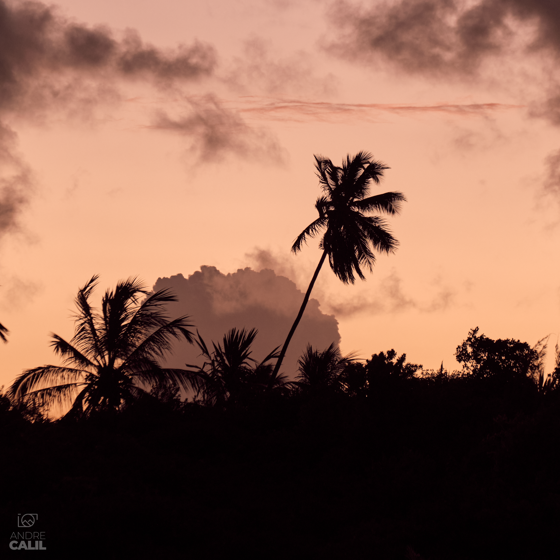
Astrofotografia: ótimo local para fotografar o céu e apreciar as estrelas.
Nascer do sol: diretamente no mar, sem qualquer formação na frente.
Nascer da lua: se for lua cheia, não perca!
Pôr do sol: emoldurado entre o Morro São José e a Pedra do Pico.
Ruínas do Forte de Santo Antonio: ótimo lugar para composições enquadrando a Pedra do Pico ou o Dois Irmãos.
Capela de São Pedro dos Pescadores: não conseguimos entrar na capela, mas rende boas fotos também.
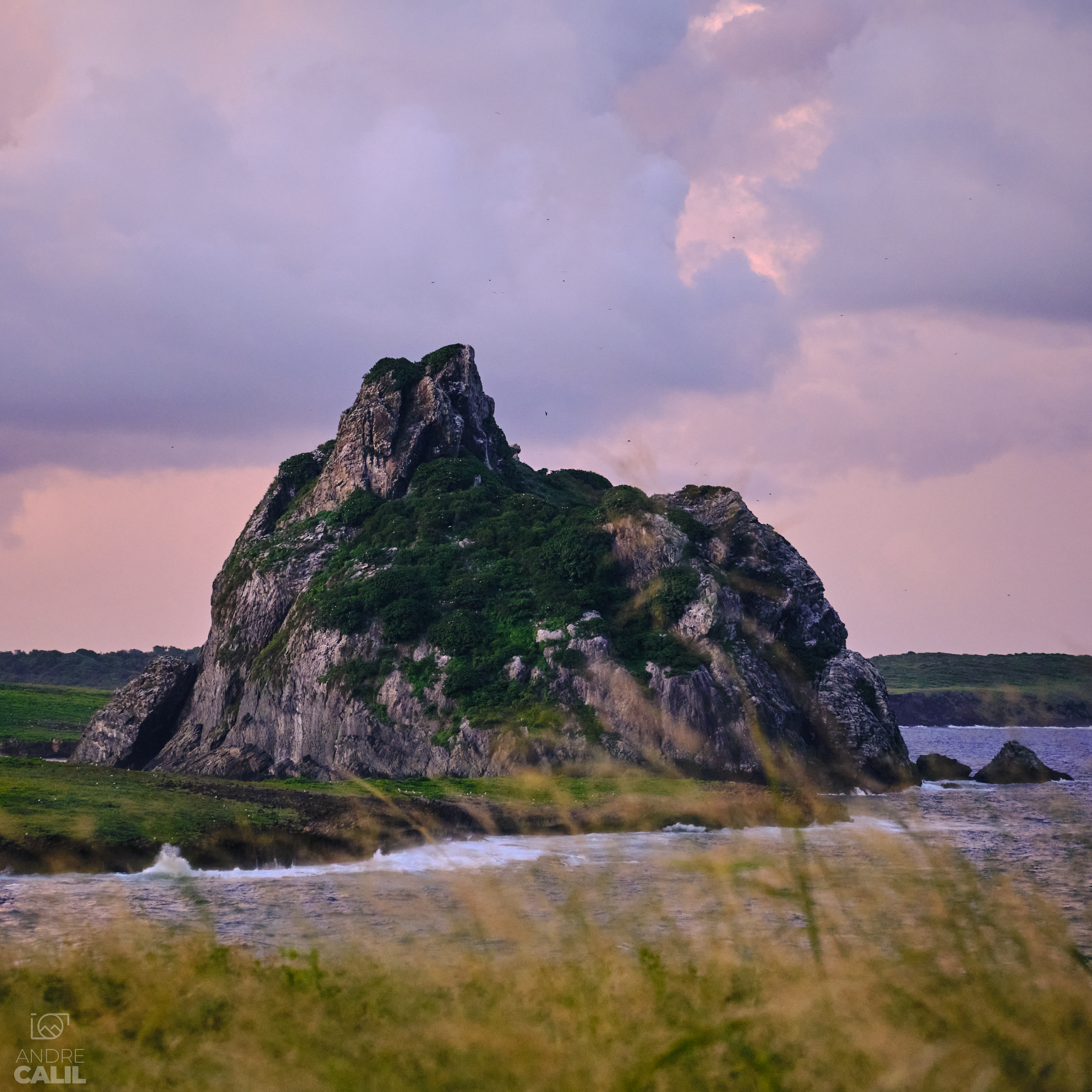
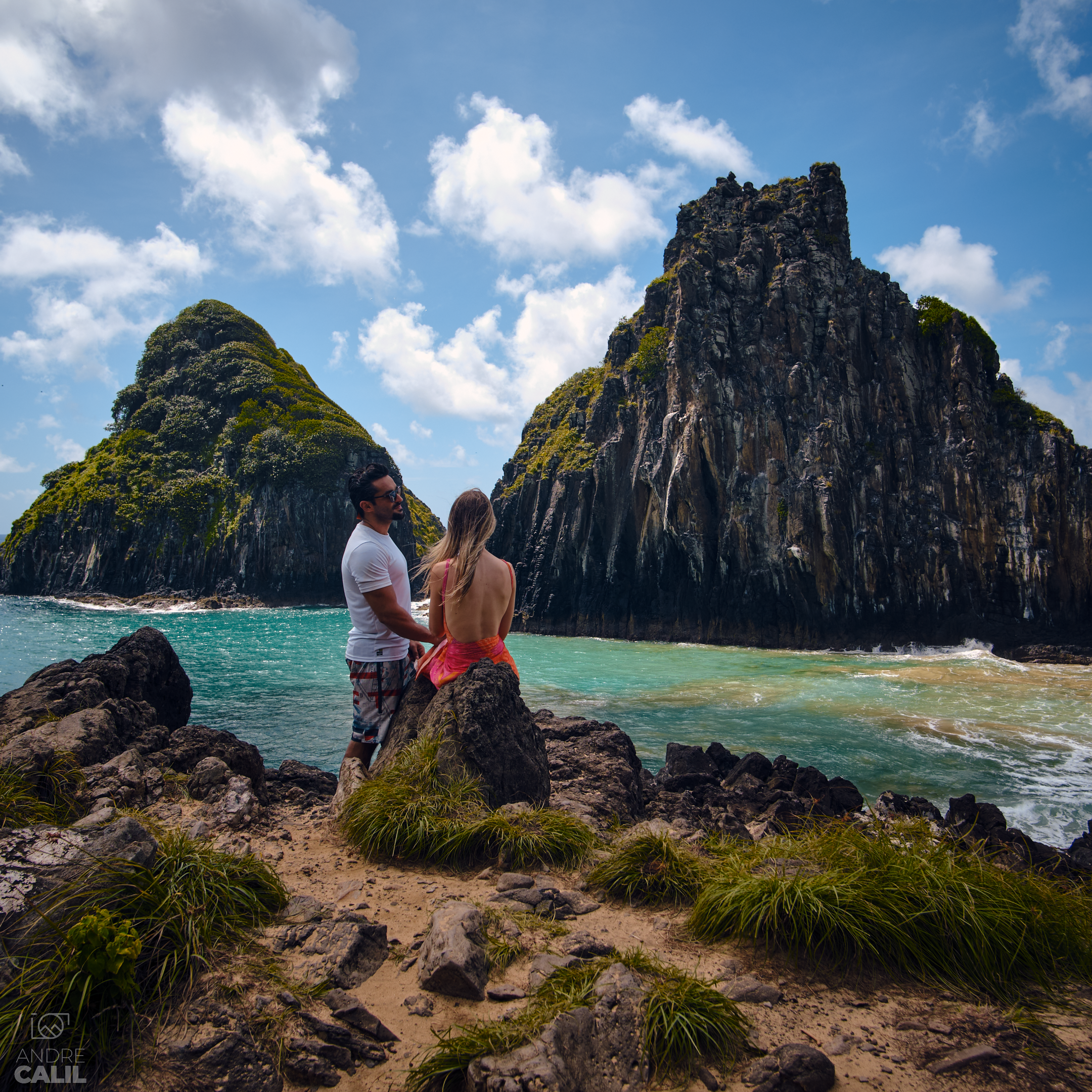
Sela Gineta: vista privilegiada para a pedra mais linda da ilha - na minha opinião.
Este local também é o ponto final da trilha da Atalaia Pontinha Caieira e início/fim do Morro São José, ambas apresentadas acima. Ou seja, você estará por estes arredores com bastante frequência.
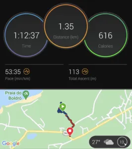
A Praia do Porto é o ponto final do ônibus e fica relativamente perto da Vila dos 30. Dependendo de onde for sua hospedagem, pode fazer o percurso a pé.
📷
Acho que ficou bastante claro: se você gosta de fotografia, vai amar este lugar.
Alimentação
Ponto bastante importante de uma viagem para Noronha. Via de regra, refeições e mercado aqui são bem caros - veremos mais sobre isso no orçamento.
Uma boa ideia é ter sempre algum lanche rápido consigo. Você pode tanto levar de casa quanto fazer compra nos mercados locais. Especialmente nas trilhas, tenha sempre algo de comer e água.
Se você estiver em uma hospedagem que ofereça café da manhã (a maioria oferece) e snacks ao longo do dia (algumas oferecem), você conseguirá se organizar para fazer apenas uma refeição externa no dia. Foi basicamente o que fizemos: um café da manhã triplamente reforçado, lanches ao longo do dia e jantar.
Os restaurantes de Noronha são bastante famosos, e com mérito. Comparando atendimento, cardápio, apresentação e sabor, é sinceramente difícil destacar algum em particular. Então, sem qualquer ordem, aqui está a lista de onde fomos:
Cacimba Bistrô
Bar do Meio
Cigana do Cajueiro
Xica da Silva
Museu do Tubarão
Valdênio: PF com preço justo e que cumpre bem o dever!
Varanda
Casa do Pirata
Bar do Cachorro
Orçamento
Praticamente toda conversa sobre uma viagem para Noronha envolverá um aspecto em particular: é caro.
Sem entrar no mérito sobre caro/barato ou vale/não vale a pena, vou apresentar nossos custos na esperança ajudar no seu planejamento financeiro.
| PARNAMAR | Acesso à área do parque | R$ 165 pp, 10 dias |
| TPA | Acesso à ilha, obrigatório | Aproximadamente R$ 80 pp/dia |
| Guia | Tabelado pela Acitur, negociar pacote | Aproximadamente R$ 150 pp/trilha |
| Canoa Havaiana | Varia se coletivo/privativo e horário | Aproximadamente R$ 200 pp |
| Ilha Tour | Varia se coletivo/privativo | Aproximadamente R$ 250 pp |
| Equipamento de Snorkeling | Máscara, nadadeira, colete. Alugamos 3 dias. | R$ 100 pp/dia |
| Atividades e Taxas | R$ 3405,70 |
| Mercado | Alguns mercados tem galão de água de 5l | R$ 303,39 |
| Restaurante | Zero álcool | R$ 3110,47 |
| Transporte | Total de todas as formas de transporte utilizadas na ilha | R$ 865 |
| Alimentação e Transporte | R$ 4278,86 |
| Aéreo | R$ 2566,05 | |
| Aeroporto | Refeições e Uber | R$ 392,94 |
| Compras | R$ 54 | |
| Hospedagem | R$ 4900 | |
| Demais categorias | R$ 7912,99 |
Total para duas pessoas, sete dias, com absolutamente tudo (até o ímã de geladeira): R$ 15.600.
Referências e Indicações
PARNAMAR: informações gerais, pagamento do acesso ao parque
TPA: recolhimento da Taxa de Preservação Ambiental
None: melhor guia da ilha!
Canoe Blue Sea: procure o Chico para o passeio de canoa havaiana
Casa Luz: hospedagem com jeitinho de casa
Santuário: aluguel de equipamento de mergulho na Praia do Porto